Every utility-scale renewable energy project must sit on land that someone controls. Before a solar farm generates a watt of electricity, before it receives an interconnection queue number, before its developer registers an LLC with the state Secretary of State — a lease or purchase agreement must exist between the developer and the landowner. That agreement is recorded in county deed and parcel records. Those records are public. And they are one of the most underused evidence sources for developer identification in the renewable energy research toolbox.
Parcel data is not a complete solution — it is one layer in a multi-source evidence chain. But in states where the ISO queue data does not publish developer names, where LLC registrations are opaque, and where project announcements lag years behind queue activity, parcel records often provide the earliest unambiguous link between a piece of land and the entity developing it.
What Parcel Records Actually Contain
County parcel records are maintained by county assessors (for tax purposes) and county recorders or clerks (for deed and instrument recording). The two overlap but are not identical:
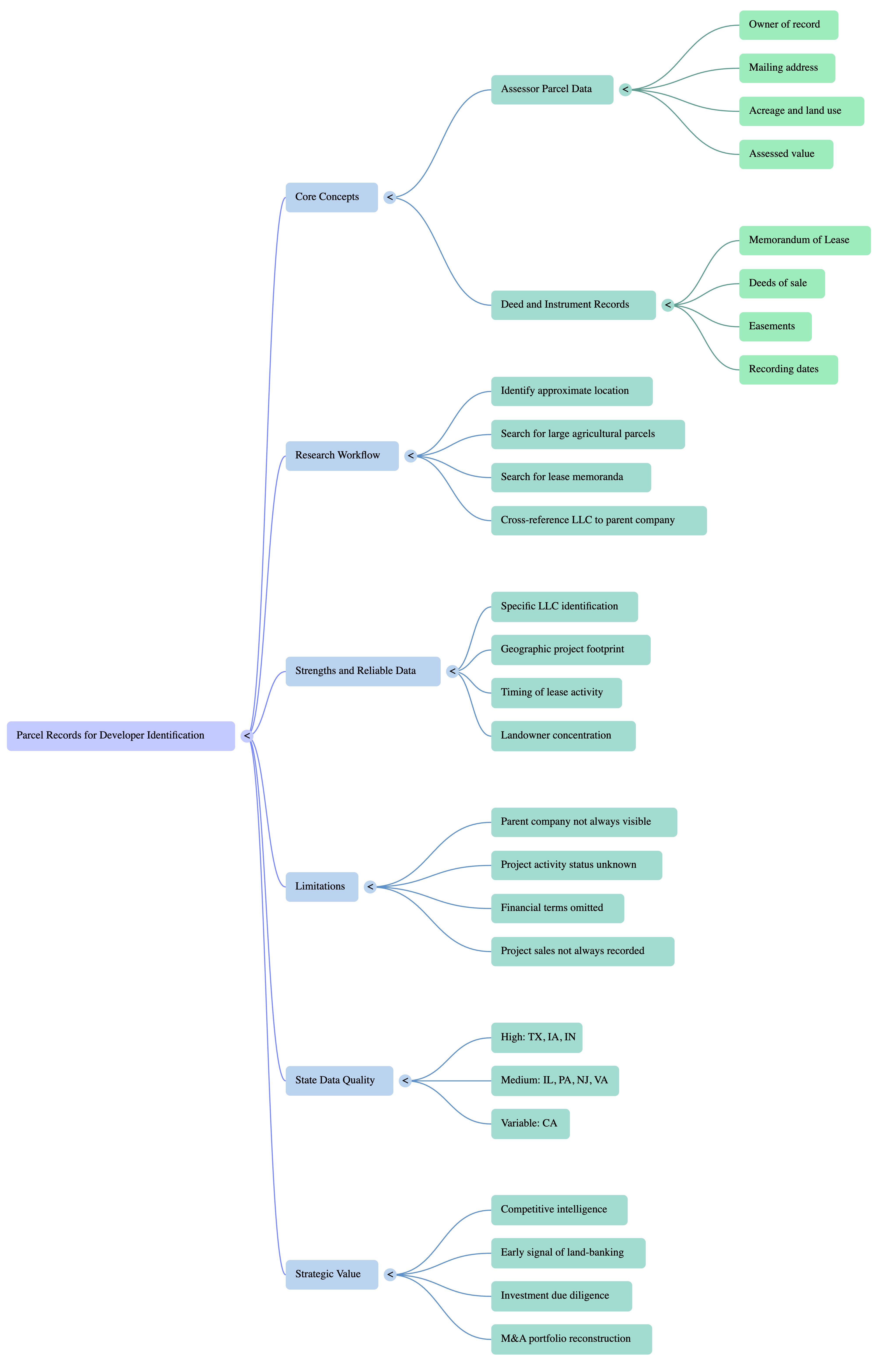
- Assessor parcel data — Contains the current owner of record for each parcel (typically a property index number, or PIN), the mailing address for tax bills, acreage, land use code, and assessed value. Updated annually. Searchable by owner name in many counties. Available as bulk GIS downloads in some states, including Texas and several Midwest states.
- Deed and instrument records — Contains every recorded transaction on a parcel: deeds of sale, deed of trust (mortgage), easements, and memoranda of lease. A memorandum of lease is a recorded notice that a lease agreement exists — it does not contain the full lease terms, but it identifies the lessee (often the project LLC) and the lessor (the landowner), confirms the lease area by legal description, and usually contains a recording date.
For renewable energy developer research, the memorandum of lease is the key instrument. When a developer options or leases agricultural land for a solar or wind project, they typically record a memorandum of lease to protect their leasehold interest from subsequent purchasers or creditors of the landowner. That recording creates a public record linking the project LLC to the specific parcels.
The Research Workflow: From Queue Project to Parcel Record
The practical workflow for parcel-based developer identification follows these steps:
- Identify the project's approximate location. ISO queue data typically includes the county, interconnection point substation, and sometimes coordinates. Where coordinates exist, a parcel map of the area around the site narrows the search. Where they do not, the county in the queue record is the starting point.
- Search the county assessor database for large agricultural parcels. Utility-scale solar projects typically require 3–10 acres per megawatt of installed capacity. A 200 MW project needs 600–2,000 acres. Searching for parcels over 100 acres in the county with agricultural land use codes narrows the candidate list. Many assessor databases allow owner-name search — an LLC name search for terms like "Solar," "Energy," "Wind," or the developer's known entity naming conventions can accelerate identification.
- Search the deed/instrument database for memoranda of lease. Searching the years before the queue application, by grantor or grantee name, can surface the recorded instruments tied to the project. Many county recorders have online search portals with keyword or grantor/grantee name search.
- Look the LLC up in the state business registry. The lessee named in the memorandum of lease is typically a project-level SPV LLC. Its state registration shows when it was formed and, in some states, who manages it. Treat that as a lead to corroborate with another independent record, not as proof of the parent company.
State-by-State Data Quality and Access
Parcel data quality and access vary significantly by state and county. This variability is the primary obstacle to systematic parcel-based research:
| State | Bulk Parcel Data | Deed Search | Quality for Developer Research |
|---|---|---|---|
| Texas | Statewide bulk download (254 counties) | County-by-county web portals | High — standardized statewide data |
| Iowa | State GIS portal | County recorder portals | High — strong county digitization |
| Indiana | Statewide parcel layer | County portals | High — standardized statewide layer |
| Illinois | County GIS portals (variable) | County recorders | Medium — Cook County vs. rural counties vary widely |
| Pennsylvania | State data portal (partial) | County recorders (67 counties) | Medium — no unified statewide layer |
| New Jersey | State GIS partnership | County recorders | Medium — urban counties well-digitized |
| Virginia | State GIS data | Circuit court clerk portals | Medium — standardized but some gaps |
| California | County assessor portals | County recorder portals | Variable — LA, SD, SF high quality; rural counties lag |
What Parcel Records Can and Cannot Tell You
Parcel records have clear strengths and limits as a developer identification source:
What they reliably reveal:
- The specific LLC that holds the lease or option on a project site
- The approximate acreage and geographic location of the project footprint
- The timing of lease activity — which helps sequence when developer interest in a site crystallized
- The landowners involved — useful for understanding whether land control is concentrated (one large parcel) or scattered (dozens of individual farm owners)
What they do not reliably reveal:
- The parent company behind the SPV LLC, without other public records
- Whether the project is still active — a lease recorded in 2019 may have been abandoned, and parcel records do not automatically reflect development status
- Financial terms of the lease — memoranda of lease are summaries, not the full agreement
- Whether the project has been sold — LLC transfer may occur without any parcel instrument recording
Why This Matters for Developers and Investors
For competitive intelligence, parcel research reveals developer land-banking activity before it appears in any other public record. A developer that has optioned 5,000 acres across three counties in a state may have queue applications pending — or may be preparing to submit them. Identifying that activity from parcel records provides earlier signal than waiting for the ISO to publish a queue application.
For investors evaluating acquisitions, parcel research validates site control claims. A developer representing that it holds options or leases on a project site can be verified — the memoranda of lease should exist in the county records if the site control is real. Missing parcel records where records should exist is a due diligence flag.
For M&A researchers tracking developer portfolios, parcel data aggregation across counties can reconstruct a developer's land bank — the set of sites under option or lease that has not yet entered the queue. That land bank represents the developer's pipeline beyond what the ISO queue makes visible.
Conclusion
Parcel records are a supporting source in developer identification — more work to access and interpret than ISO queue data or state business filings, but often the only source that provides site-level proof of developer presence before a project enters public view. States with good bulk parcel data access (Texas, Iowa, Indiana) support systematic large-scale analysis. States with fragmented county-level data require county-by-county research that is harder to automate but still yields the same evidence quality.
For what state business filings show about the LLCs named in a lease, see Secretary of State LLC Filings: The Hidden Evidence Layer for Solar Developer Research. For why projects sit in SPVs at all, see What Is an SPV in Renewable Energy?
Land records are one of the state and local public records Load Factor reads, alongside grid-operator filings, federal filings, corporate disclosures, plant and market data, news, and many more, to identify the developer behind every project in its 41,000+ project database. A developer shows Two sources agree only when two or more independent primary sources name it. Browse projects to see the evidence behind each one.